logo
lat rus
My Vietas
draugiem.lv
Register
Why register?
Forgot password?
Shortcuts
Hotels in Latvia
Bookable accomodation
Most notable places
Palaces, castles ...
Country Holidays
Restaurants, caffes
Museums
Accommodation in Riga
Info Bureaus
Theaters
Car Rental
Rīga
Hotels in Riga
Calendar
April
15 16 17 18 19 20 21
22 23 24 25 26 27 28
29 30
May
1 2 3 4 5
6 7 8 9 10 11 12
13 14 15 16 17 18 19
20 21 22 23 24 25 26
Booking with discount
Online 283
Guests - 283
Registered members - 0
Partners
In touch with Vietas*lv!
Clients: +371 728720
Info: +371 29111411
e-mail: [email protected]
Skype vietas_lv
SHARE THIS CONTENT
Municipality

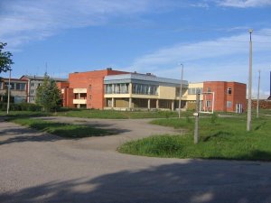
Rundeni Parish Council

Contacts
+371 65751435
Description
The Rundēnu parish is located on the Height of Latgale. The most part of parish is covered by hills of Razna, in a southeast - by hills of Dagda. The highest part of Rundēnu parish is a northern part, which forms a watershed between the rivers Daugava and Velikaya (basin of Lake Pskov). Also on a height there is a western part, which closely approaches to massif of Lielais Liepukalns. The highest hills are Pentjušu Hill, and also hills to the north from Kovaļiški at Sūnupļava and at Rudzīši. The biggest lake is Lake Bižas. Smaller lakes: Bezersļesjes, Aunejas, Testečkovas, Loboržu, Audeļu (Kovaļišku), Bļižņevas, Glušeņa, Pakalnu, Vorzovas, Kazeņa, Rudzīšu. On territory of parish flows the Saryanka River, which runs into Daugava. Other small rivers of the rural community: Kazeņa, Siņica, Volčica, Vonogupīte
Interesting objects around
349 m Manor development Pakalni Manor
402 m Poststation Rundani
667 m Manor development Rundeni manor
5.4 km Poststation Brodaiza
Nearest in category(-ies):
Organisations, institutions
Comment this object (0)
Visited 2695 times
Pictures (1)
If You are registered User You can upload Your picture for this object if You have some.
Register

Location on Map
Weather in Rundeni
© 2005-2024 SIA VIETAS Top.LV Rambler Top100