Geological object

Korkulu dry riverbed and underground river

Serenes par. > Jaunjelgavas county > Zemgale reg.
Description
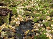
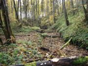
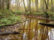
Korkuli stream is small but well manifested river with sandy bed. It winds through 10 - 15 m deep ravine with primeval broadleaved forest. Some 300 m below Korkuli hoemstead river disappears underground through several sinkholes. Here forms some 0,5 km long underground river. The outlet of this river is especially impressive during the high water in spring time. Near Korkuli River there is vertical pit made by geologists in order to investigate the underground karst cave found during the geological investigations around Aizkraukle dam (for hydropower plant).
Interesting objects around
Geological object
Serene nature object (caves and rock) 2 859 m
Forest, wood
Beku pine forest 1.5 km
Technical object
Plavinas Hydroelectric Station 6 1.7 km
Poststation
Serene 2.5 km
Municipality
Serene Parish Council 1 2.9 km
Geological object
Cepli dolomite outcrop 3.0 km
Educational institution
Aizkraukle art school 3.4 km
Nature walk
Tourist trail 3 3.6 km
Tree
Kalna ziedu (Hill Flowers) Sacrificial Oak 1 3.6 km
Curch
Aizkraukle St.Theresa of the Child Jesus Roman Catholic Church 4 3.7 km
Monument
"Lacplesa cina" - Monument ("Fight of Lacplesis ") 3.7 km
Municipality
Aizkraukle Province Council 2 3.8 km
Municipality
Aizkraukle Regional Council 3.8 km
Monument
Monument to The Killed in World War I 1 3.9 km
Poststation
Aizkraukle 1 3.9 km
Nearest in category(-ies):
Nature
Geological object
Serene nature object (caves and rock)
Forest, wood
Beku pine forest
Geological object
Cepli dolomite outcrop
Tree
Kalna ziedu (Hill Flowers) Sacrificial Oak
Geological object
Oak quarry