FallsGeological object

Rauna Staburags, Waterfall

Contacts
mapx.map.vgd.gov.lv/geo3/Ukr/index.htm
Rauna  > Raunas par. > Raunas county > Vidzeme reg.
Description
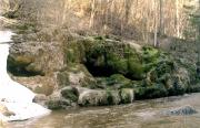
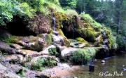
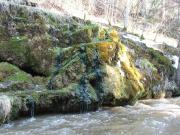
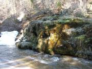
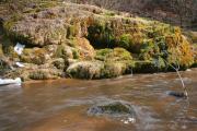
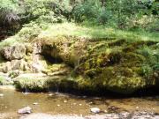
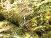
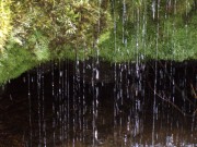
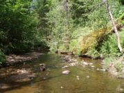
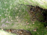
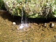
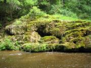
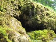
Unusual formation of postglacial times. Springs have formed a cemented layer of lime along the steep bank of Rauna river. This formation is called Staburags. Springwater continues to flow over Staburags, thus increasing it slowly. Growth of Staburags has started some 800 years ago. Now this formation is some 35 m wide and 4 m high. Earlier there was a lot more water flowing over it. Over the last years there have been summers without water here. Staburags has been degraded over the last decades due to the unorganised tourism. There are laid flowers on Staburags thus damaging the balance of microflora here. Most people try to step on Staburags - this damages the monument very much.
Interesting objects around
Manor development
Rauna Rectory 377 m
Park
Rauna Rectory Park 583 m
Castle mound, hillfort
Tanisa hillfort 5 806 m
Cave
Rauna Devil's Cave 4 816 m
Tourism information
Rauna Tourist Information point 902 m
Monument
"Kokletaja" ("Kokle player") 1 969 m
Antic graveyard
Upmalu ancient burial ground 977 m
Poststation
Rauna 1.0 km
Municipality
Rauna Parish Council 1.1 km
RuinsSight Tower
Rauna Castle Ruins 13 1.2 km
Curch
Rauna Evangelic Lutheran Church 6 1.2 km
Curch
Rauna Roman Catholic Church 4 1.8 km
Antic graveyard
Balozkalns medieval graveyard 2.0 km
Geological object
Pavulu gravel quarry 2.5 km
Antic graveyard
Jaunlaivinu medieval graveyard 2.8 km
Nearest in category(-ies):
Nature
Park
Rauna Rectory Park
Cave
Rauna Devil's Cave
Geological object
Pavulu gravel quarry
Hill
Sparinu hill (131 m)
Hill
Bridegas Hill (186 m)